Cultural Crossroads

Deir el-Balah and the cosmopolitan culture of the Late Bronze Age
After the Six-Day War in 1967, the Old City of Jerusalem became accessible to Israelis for the first time in nearly 20 years. For many who, like me, had grown up in Jerusalem during the British Mandate, when one could travel freely between the Old City and the new, an intense curiosity mixed with nostalgia frequently brought us through Jaffa Gate to those vaulted cobbled streets and alleys dotted with colorful shops and markets that give the Old City its unique charm. Antiquities shops were abundant—as they always have been and as could be expected in a country where one literally trips over history at every turn.
I could hardly fail to notice that many of these antiquities shops were flooded with Egyptian scarabs and jewelry, alabaster and bronze vessels, and fine Mycenaean and Cypriot pottery. All of these artifacts were typical 14th- to 13th-century B.C. burial offerings. But it wasn’t until someone showed me the clay lid of an anthropoid, or human-shaped, coffin acquired in one of these shops that my interest was sparked.
Anthropoid coffins were found in Palestine in the 1920s at Beth-Shean, in the north, and at Tell el-Farah (South), about 20 miles southeast of Gaza. Like mummy cases, anthropoid coffins originated in Egypt in the Middle Kingdom (c. 2000–1785 B.C.).a They continued to be used—and became even more popular—during the New Kingdom (c. 1570–1085 B.C.) and even later. They appear in Canaan during the New Kingdom, when Egyptians (or their mercenaries, among them Philistines and perhaps some of their kindred Sea Peoples) manned the garrisons and strongholds that dotted the important international coastal trade route stretching from the Nile Delta through Canaan to Mesopotamia.
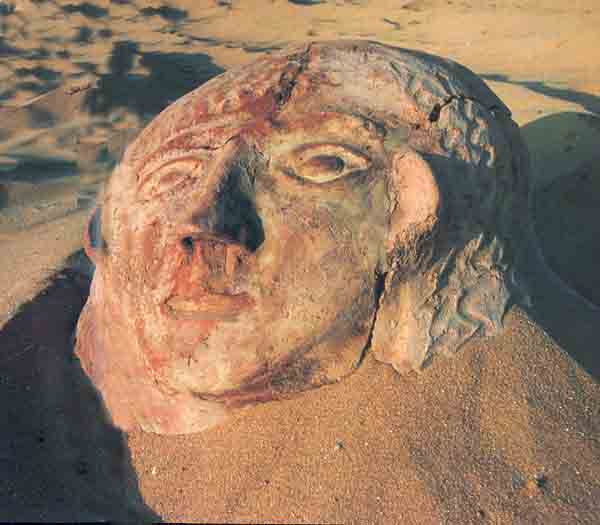
The huge human face gazing up at me from the anthropoid coffin lid acquired in the Old City was undoubtedly unearthed during illegal digging in a rich, hitherto unknown cemetery from the Late Bronze Age (1550–1200 B.C. in Palestinian chronology). Examining the lid closely, I noticed fine grains of yellow sand embedded in the clay. That kind of sand is characteristic of the coastal area around Gaza and northern Sinai. Later I went back to the antiquity shops in the Old City to look at the burial gifts I had seen for sale. The same yellow sand was clinging to these artifacts.
At that time, the entire Gaza Strip was off-limits to civilians. Nevertheless, I was determined to locate the cemetery. After countless inquiries my persistence was rewarded. Moshe Dayan, then minister of defense, located the general area that had yielded the artifacts near Deir el-Balah, a little town south of Gaza and about a mile from the Mediterranean Sea. The military authorities gave me permission to visit it in July 1968. I did not find any tombs, but I did see potsherds and coffin fragments strewn over a field. The owner of the land, a lawyer from Gaza, invited me in for a cup of rich, dark Arab coffee. Then I returned to Jerusalem.
For a while the tomb robbers suspended their work, but all too soon, more of the precious burial gifts began to surface in the antiquities shops. The tomb robbers, in collaboration with Jewish and Arab antiquities dealers and collectors, were having a field day—and the cemetery was being rapidly depleted. It was clear that only a salvage excavation could save the situation, but political conditions precluded this; my hands were tied.
Unable to excavate, I decided to document the coffins and burial gifts already in private collections and museums.b I eventually tracked down nearly 50 coffins and their lids, as well as a variety of artifacts that I and a group from Hebrew University catalogued, photographed and studied. By the time we had finished, it was clear that this still-unlocated cemetery had yielded the largest and richest group of anthropoid coffins and burial offerings from Canaan ever discovered.
Not until 1972 was my expedition finally given permission to excavate.c We made a deal with the Gaza lawyer: In exchange for the right to excavate his land, we would return all excavated land to him after ten years in condition for agricultural use, regardless of whether the land had been arable before. It was an eminently fair quid pro quo: The earth would enrich us, and we would enrich the earth.
Between 1972 and 1982, we fielded 15 excavation seasons of various lengths, always uncertain of when the area would be secure enough and whether we would have enough people to go down to the site. This was no ordinary excavation. No tell rose visibly out of the landscape to announce the presence of ancient life. On the contrary, the ancient site was entirely invisible, covered by more than a millennium’s worth of shifting sand dunes.
When we went to excavate the site in 1972, all the sherds and coffin fragments that I had seen in 1968 had been removed and the field plowed over. The owner of the land identified various places where coffins had been illegally uncovered. On this basis we drew up a crude map of the site. Except for this map, we had little to go on.
A group from Tel Aviv University, headed by Itzhaq Beit-Arieh, who is well known to BAR readers,d made a preliminary survey of the area and dug a number of trial probes. In one of the probes, Beit-Arieh uncovered an anthropoid sarcophagus made of local limestone rather than clay. It had been broken into shortly before we found it. When I saw it, the lid had been smashed in. Shortly afterward, it disappeared altogether.
Our best guide turned out to be a Bedouin rais, or leader, named Hamad. In the first weeks Hamad invariably led us to tombs that had already been plundered. It was clear that Hamad and his followers knew the site and its treasures well. Finally, after some judicious haggling, Hamad led us to the edge of the plowed area where, probing with a long screwdriver, he uncovered a storage jar buried upright in the sand. We recognized the storage jar as an ancient grave marker.
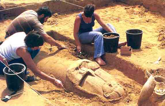
Beneath the jar, in a patch of dark soil, we soon saw two well-modeled folded clay hands. We carefully brushed away the dirt and confronted our first undisturbed coffin. It was, in truth, a moment of awe.
We designated this coffin Tomb 114. A shallow depression approximately the same shape as the coffin had been cut into the natural marl, big enough for burial offerings and the coffin. An Egyptian alabaster vessel had been laid on top of it. Then the coffin had been covered with sand and a number of large clay vessels lined up along the surface of the grave. At the head of the coffin stood the Canaanite storage jar that Hamad had found—a four-handled vessel with a juglet inside and its opening covered with a bowl. Beside it stood a small Egyptian-style jug. At the foot of the coffin, a group of three large vessels stood side by side: another Canaanite storage jar, a Mycenaean three-handled pyriform jar (a pear-shaped jar with a narrow neck and loop handles) and an elegant white-slipped Egyptian variant of the Canaanite jar.
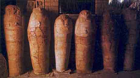
From the coffin lids we had already studied, we knew that the figures modeled on them were of two distinct types: naturalistic (second photo below) and grotesque (first photo below). The distinguishing feature of the naturalistic type is the clearly marked outline of the face. The lack of such an outline is what gives the grotesque type its bizarre, somewhat caricaturistic, effect. The coffin lid from Tomb 114 was an unusually fine example of the naturalistic type, with well-defined head and shoulders. The features were modeled in relief and were well proportioned: large eyes, arched eyebrows, a straight nose and full lips. A plain wig fell over the shoulders and a lotus flower extended from the center of the wig down to the forehead. Stylistically the coffin was the work of an artisan steeped in Egyptian tradition.
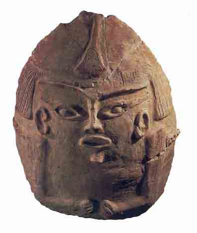
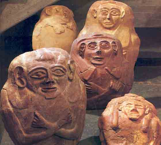
Our first thought was to take the coffin to Jerusalem and examine it there under better conditions. We had even brought along a stretcher for carrying the coffin. Unfortunately, on closer scrutiny we saw that the coffin was cracked in dozens of places and appeared to be held together by the sand that had seeped into it over thousands of years. We had to open the coffin just as it lay.
Inside the coffin, beneath the sand that had filled it, were the skeletons of a man, a woman and a child. A multiple burial was entirely unexpected, but this was what we found in all the coffins subsequently excavated. The articulation of the bones showed that the skeletons had been placed in the coffin before decomposition and that they had remained undisturbed.
Our anthropologist, Baruch Arensburg, could give us only two possible explanations for the multiple burials: Either these people had died in an epidemic and had been buried in family groups, or when these men died their families were simply interred with them.
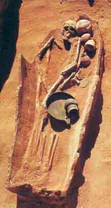
The coffin also contained a number of bronze objects—a mirror placed near the head of one of the skeletons, a bowl, a ring-handled strainer and a small jar. Three bronze knives were laid near the legs—a cutout knife (a knife believed to have been used for cutting linen, usually found in Egyptian burials of women), a slender knife and a knife with a handle in the form of an animal’s foreleg, complete with cloven hoof. Traces of cloth still adhered to some of the bronze objects, indicating that the burial gifts had been wrapped in linen.
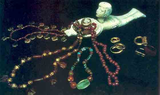
Near the skulls lay carnelian and gold beads, a golden amulet and a crimped crescent-shaped gold earring. Three scarabs were also found, two still in their gold settings and one in a silver sickle-shaped ring. The latter bore one of the names of Ramesses II in Egyptian hieroglyphics.
Near one of the skeletons’ hands we found five bone and stone pellets incised with various signs. One bears two parallel incisions on the edge, another has a circular incision around the edge, a third has crossed incisions, and the remaining two have four roughly parallel incisions ending in round drilled indentations. They may be game pieces. Small round pebbles were discovered among the burial gifts in a Late Bronze Age burial at Tell Abu Hawam, in present-day Haifa; the excavator, Emanuel Anati, has suggested that they were used in games. Similar pellets have been excavated at Megiddo, Lachish and Gezer.
The discovery of the tomb was enormously exciting for us. It was the first time we saw an anthropoid coffin untouched and in situ. Suddenly we were seeing with our own eyes what we had only been able to conjecture from our years of cataloguing and studying illegally excavated finds. Things were beginning to fall into place.
Eventually we found three more anthropoid coffins and their accompanying assemblages of burial offerings in situ at Deir el-Balah. We also located hundreds of plain burials, bodies simply laid in the ground without coffins.
The second tomb with an anthropoid coffin, Tomb 116, surprised us: It had apparently been plundered in ancient times, not long after the burial itself. The anthropoid coffin was intact, but most of the burial gifts had been removed. Everything was in disarray, including the skeletal bones. Only the less valuable burial gifts—pottery, carnelian beads, gaming pieces and a seal relating to Ramesses II—had been left behind by the ancient tomb robbers.
The face mask on this coffin lid had been modeled separately and then applied to the lid. The face had a high, curved forehead; arched eyebrows and eyelids; a broad turned-up nose with deeply indented nostrils; a beard similar to those on statues of Osiris, the Egyptian god of the dead; and a long wig parted in the center. The face on the lid, like the first one we excavated, was clearly of the naturalistic type.
Our third find, Tomb 118, contained the skeletons of a man and a woman laid together in a pose so romantic we immediately nicknamed them Romeo and Juliet. The tomb contained a rich assortment of burial gifts, including one set of alabaster objects and another set of bronze objects. The alabaster set included a lotus-shaped goblet decorated with petals and a cosmetic spoon with a handle in the shape of a nude swimming girl. The bronze set consisted of a platter and jug, the latter incised with lotus motifs on the handle. These vessels were part of a type of wine set known from Egypt and Canaan during the New Kingdom. In addition, we found 20 palmette gold pendants (once part of a necklace), gold and carnelian beads, and five pairs of earrings—some solid gold crescents, others braided gold loops with fruit-shaped drops. One of the skeletons still wore a carnelian ring. Finally, the burial gifts included a large number of scarabs and amulets.
One might expect such rich burial gifts to be enclosed in the finest and fanciest coffin, but this was not the case. The coffin of Romeo and Juliet had a very crude lid, not at all commensurate with the wealth and quality of the gifts inside.
A fourth in situ burial, Tomb 304, was found a few years later, after we had begun excavating the settlement where the coffins were made. Inside this coffin we discovered the tangled skeletons of two men and a woman. The woman’s forehead had a large hole in it, possibly the result of trepanation, an ancient form of brain surgery. No gifts accompanied the burial. And the coffin lid did not fit the coffin body. Although it bore a delicate, beautiful face, the lid was clearly reused. Apparently, this sort of recycling was considered sufficient for the burial of less affluent people whose survivors could not afford gifts.
From these burials and from what we had learned from our study of the coffins previously looted from the site, it was evident that the coffins had been buried in groups of three or more, 10 to 15 feet apart, with hundreds of simple burials between them. Each burial had been marked aboveground by a Canaanite storage jar placed at the head of the coffin. Over the course of time, these grave markers were covered with sand.
All of the coffins were found in shallow depressions cut roughly into the coastal sandstone (kurkar) or red sand deposits (hamra) and oriented more or less westward, towards the Mediterranean. The coffins were cylindrical and ranged in length from 5.25 to 6.6 feet, with a circumference of about 5.6 to 7.2 feet at the widest part. The coffins tapered toward a rounded or rectangular flat base, which in some cases protruded to accommodate the feet. The upper part was closed by a removable lid 16 to 35 inches high and from 20 to 24 inches wide, on which facial features and arms were modeled in high relief.
The coffins were manufactured by the coil method, which is often used in making large vessels. In this technique, chunks of clay are rolled into coils of varying thickness and length and then built up into the desired shape.
The coffin lid was cut out of the leather-hard clay before firing and thus fit the opening perfectly. In some cases the coffin had a row of small round holes in the back and either a round opening or another series of small round holes in the base, apparently to allow for the drainage of bodily fluids. Another hole at the top was perhaps intended to allow the soul to escape.
The coffins were fired in an open fire at a low temperature, which would explain the sometimes crumbly and mottled, and always brittle, nature of the material. Neutron activation analysis showed that the coffins were made locally.e
Far greater attention was paid to the firing and finishing of the lids. These were fired at high temperatures, most probably in kilns. In a few cases, traces of paint still survive on the lids. Both the modeling of the facial features and the painting probably occurred between the first and last firings.
The exquisite burial gifts were wrought primarily in Egyptian styles and reflected the affluence of the deceased—or the deceased’s survivors. The deceased were evidently Egyptian or under Egyptian cultural and religious influence. Some of the coffins bore Osiride insignia: Osiris, Egyptian god of the dead, is depicted as having a long, narrow rounded beard, wearing the atef crown and clutching a scepter in his fists. In a number of coffins, the Osiride elements were abstracted to the point of caricature, however, perhaps indicating that the people of Deir el-Balah were losing touch with the cultic significance of these Egyptian symbols. Still, among the burial gifts were ushabti figurines, a common Egyptian burial gift. Ushabtis were supposed to do the work assigned to the deceased in the next world.
The cemetery seems to have been in use from the 14th century B.C. to the last phase of the Late Bronze Age, about 150 years later. The period of Ramesses II (1304–1237 B.C.) was especially well represented.
The finds from Deir el-Balah strongly substantiate our understanding of the Late Bronze Age as a cosmopolitan era marked by extensive international maritime trade and commerce as well as a mixing of cultural influences.
In digs, the more you find, the more questions there are to answer. Who were the people buried in this cemetery? Where did they live? Were they Canaanites steeped in Egyptian culture, or were they Egyptians living abroad?
While a small contingent of our workers continued excavating the cemetery, others began to open up areas bordering the sand dunes to the northwest, southwest and southeast in an effort to discover the limits of the cemetery. In each of these areas, however, the diggers found more of the cemetery continuing under the dunes. As a result, it was impossible to determine its actual boundaries.
Meanwhile, the rest of the team began searching for traces of the elusive settlement. Considering the opulence of the burial gifts, we hoped to find an extensive and wealthy settlement or at least the village of the workmen who had provided the cemetery with its strange coffins.
In an orange grove a few hundred yards from the cemetery, at the foot of a massive sand dune, we found sherds of 13th-century pottery similar to what we had found in the tombs. We soon uncovered an earthenware oven with cooking pots beside a mudbrick wall. The remains of another mudbrick structure contained pottery, grinding stones, pestles and mortars, and flint knives, all contemporaneous with and stylistically linked to the finds in the cemetery.
Could such humble mudbrick buildings, we wondered, be the homes of the wealthy people buried in the cemetery? Our answer came from Hamad, who by then had become an indispensable part of our team: “My own house is made of mudbricks like these,” he told us, and we knew that he was far from poor. Unfortunately, the mudbrick walls soon ran under the dunes, and the sand trickled down on us as we dug further into them. We knew it would be difficult, probably dangerous, and maybe even impossible, to dig through nearly 40 feet of accumulated dunes.
Besides, we had not yet obtained permission to dig in this area from the man who owned the orchard. He was less tractable than the Gaza lawyer. Finally, we developed an idea: We would bring in heavy equipment to clear the area of dunes, sell the sand and give him the money; within five years we would fill in the excavated areas with good topsoil, thus providing him with new tracts of arable land. He agreed to this proposal.
With heavy earth-moving equipment, we cleared an area of 2,400 square yards down to the settlement’s occupation level. This was the first time in either Palestinian or Israeli archaeology that such extensive sand accumulations were removed to make excavation possible.
A year later, excavation of the settlement began.
Digging for the settlement was very different from digging for the burials. It was almost impossible to distinguish the buildings from the surrounding earth. The walls were made of unbaked mudbrick and did not have stone foundations. As we opened one square after the next, trying to stay on the same level, we became increasingly frustrated: We were getting different messages from every square. It was like a puzzle whose pieces didn’t fit together. We had no point of reference. Usually, after a period of digging, one can say, “This is like Lachish, or Megiddo, or Beth-Shean.” Here it was as if we were in an unknown country. We suspected that if we were accustomed to digging in Egypt we would have been more familiar with the material.
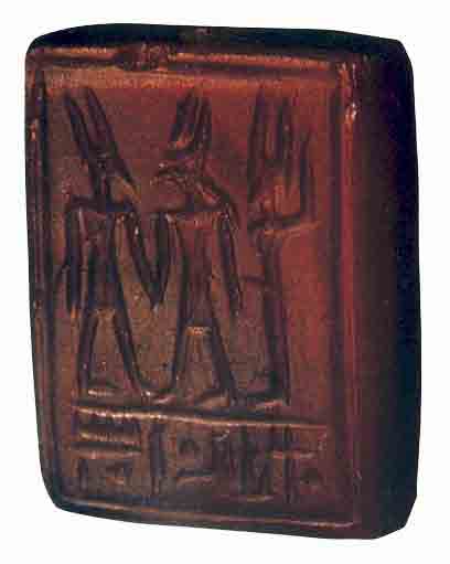
The discovery of three large kilns and one small, indeed miniature, kiln suggested that we had come upon an artisans’ quarter or village. We also found a large clay seal of the Egyptian god Ptah in low relief. Ptah was the god of artisans and burials. The seal was locally made and apparently stamped into something soft. At Tell el-Amarna, in Middle Egypt, similar seals were used to stamp bread.
In another area we found kilns beneath what appeared to be a fill containing strange layers of black rubble, ashes and animal bones. The fill continued down to an enormous depth and held vast amounts of pottery sherds—Byzantine, Iron Age, bichrome and debased Philistine, and red-slipped Israelite—but all mixed up! Apparently we were in a crater that had been filled in a later period. At first the geologists working with us believed it was a natural depression, perhaps caused by erosion. Baruch Brandl, who is both an archaeologist and an Egyptologist, believed it had to be man-made because of its regular edges. As we proceeded to excavate the fill, we discovered that at a lower level there were built-up inner walls with watermarks on them. We concluded that the crater was man-made and began calling it the reservoir or pond.
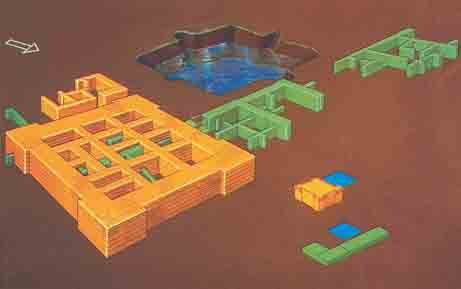
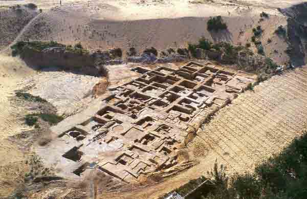
Not far from the reservoir, we discovered the major settlement area. We found nine layers of occupation for the settlement, called Strata IX–I.
As we looked down from the highest point on the sloping dunes surrounding the excavations, the settlement looked like a labyrinth. After years of weaving our way carefully through the finds of square after square, we were eventually able to propose the following stratigraphy and history of the site:
The earliest stratum at Deir el-Balah (Stratum IX), where the first buildings were erected on virgin soil, dates to the middle of the 14th century B.C. The closest parallels to this stratum have been found at Tell el-Amarna, the capital city of Pharaoh Akhenaten (1379–1362 B.C.). The reservoir was apparently built in this period and remained in use through Stratum VII.
Our next highest level (Stratum VIII) dates to the end of the 14th century B.C., the period of Horemheb (1348–1320 B.C.), who had served as general under Akhenaten and Pharaoh Tutankhamun (1361–1352 B.C.). Under Horemheb, Egypt re-embarked on the road to imperial preeminence in Canaan.
Above this level, in Stratum VII (late 14th to early 13th century), we found a fortress (superimposed on the Stratum IX buildings), which related to the period of Pharaoh Seti I (1318–1304 B.C.).
The next three levels (Strata VI–IV) contained the artisans’ village, built above the reservoir, which had been filled in. The finds could clearly be related to the anthropoid sarcophagi and other finds in the cemetery. These levels covered the period of Ramesses II (1304–1237 B.C.) up to the end of the 13th century B.C.
Then came the Philistine (12th–11th centuries B.C.) and Israelite (10th–9th centuries B.C.) levels (Strata III and II), after which the site was abandoned for 1,300 years—until the Byzantine period, in the 4th century A.D. (Stratum I). After the Byzantine occupation, the site was again abandoned, this time to the creeping sand dunes.
The closest parallel to the earliest level, Stratum IX, as noted, was Tell el-Amarna, one of the most important sites in Egypt. Pharaoh Akhenaten, who unsuccessfully tried to introduce the worship of only one god, Aten, into Egypt, built his capital there (after his death it returned to Thebes). Also, a very famous cache of nearly 400 diplomatic letters was found there. Written in Akkadian, the lingua franca of the day, these clay tablets record the correspondence between the Egyptian court and Egypt’s vassals in Canaan during the 14th century B.C. Until recently, these letters were thought to reflect a period of great unrest and instability.
Although Deir el-Balah was designed and built on a much smaller scale than Amarna, like Amarna, it appears to have been constructed in a brief period of time at a spot previously uninhabited. Deir el-Balah, whose ancient name we do not know, must have been an important Egyptian outpost during Akhenaten’s reign.
The main architectural feature of Stratum IX was a large residence very near the man-made pool. The presence of a pool next to the building complex was a common feature not only at Amarna but at many New Kingdom estates. Numerous wall paintings of estates with pools as their central feature have been found in tombs at Amarna and Thebes. A number of such pools—generally difficult to isolate in digs—have been excavated at Amarna.
Filled with fish and surrounded by gardens and rows of graceful trees, the pools on these large Egyptian estates apparently served aesthetic as well as utilitarian purposes. The Deir el-Balah pool was used primarily for practical purposes, serving as the main water supply for the area during several phases of its existence. However, it may also have been a sacred lake, a feature well known in Egypt.
The reservoir or pool covered about 22 square yards and was more than 15 feet deep. The clay removed during its construction was probably used to make the mudbricks for some of the nearby buildings.
How the pool was filled remains a mystery. At Tell el-Amarna the water table lay about 20 feet below the bottom of the pool, which was filled by a well. A device known in modern times as a shaduf retrieved the water from the well. Known as far back as the 16th century B.C. (the XVIIIth Dynasty), a shaduf consists of a suspended and weighted arm supporting a bucket or pouch that could be lowered into water and filled. No water table was accessible in this way at Deir el-Balah, however; the pool may have been filled with rainwater instead.
The building complex excavated beside the pool may have served as a single residence. Composed of three mudbrick buildings with outer walls more than 3 feet thick, it contained about 20 rooms and may have been part of a larger complex extending north and west under the sand dunes.
In one of the rooms we uncovered four worked stone bases. Each one was about 5 inches high with sloping sides and a slight depression on top. We could not determine what they were until we studied the excavation reports from Tell el-Amarna.
British archaeologist Sir Flinders Petrie first cleared Tell el-Amarna for excavation in 1891–1892, after which British, German and French archaeologists excavated the city extensively, uncovering, among other things, some 270 private dwellings. New excavations are being carried out today by a British team. Unlike Thebes, where crowded conditions dictated multistoried buildings, the Amarna dwellings had only one floor. The nobles lived in spacious villas with landscaped gardens, while workers were lodged in rows of simple cottages. The typical private house at Amarna was square, with a central hall rising higher than the surrounding rooms. A staircase, accessible from the central hall, led to the roof. Most of the dwellings in Amarna were constructed according to the same basic plan with some standard deviations.
Although the plan was fairly innovative, these buildings retained some traditional Egyptian features, one of which was a bedroom niche, an architectural element that can be traced back as far as the 18th century B.C. (XIIth Dynasty). In one of the bedroom niches at Amarna, the excavators found a set of stone bases identical to those we discovered at Deir el-Balah. The Amarna bases were apparently used as supports for a bedstead. Thus, we concluded that the room at Deir el-Balah where the stone bases were found may have been the master bedroom of the residence.
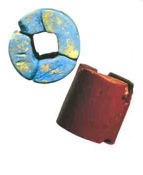
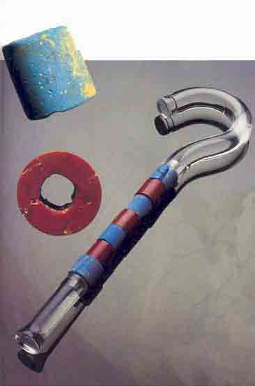
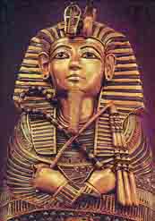
A number of rooms in the Stratum IX building at Deir el-Balah had well-preserved beaten-earth floors on which we found a variety of objects, including a large quantity of both locally made and imported pottery. Egyptian vessels made up about 80 percent of the total. Of special interest were ten pieces of carnelian or jaspar (both are reddish varieties of quartz) and blue frit, a material used for making glazes, enamels, soft porcelains and glass. They were too large to be beads for a necklace, and they had square holes, which are the wrong shape for a necklace. Rather, the pieces were from a scepter or flail made of alternating pieces of blue frit and carnelian mounted on a square rod. Very few scepters or flails have ever been recovered in excavations, so we were especially pleased with our find. Often depicted in Egyptian art, the flail and scepter were symbols of authority and the insignia of the god Osiris. Usually only rulers, chiefs and viziers possessed them. The closest parallel to our rare find comes from the tomb of Pharaoh Tutankhamun (1361–1352 B.C.), where a number of scepters and flails were excavated. Indeed, one set from Tutankhamun’s tomb was made of beads the same size as those we found at Deir el-Balah, and a square rod found in the pharaoh’s tomb was precisely the right dimensions for our chunks of quartz and frit. Based on our discovery of this important symbol of authority, we identified the surrounding building complex as either a governor’s palace or an administrative residence.
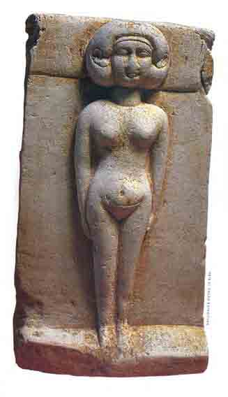
Among the other finds were molds for manufacturing the nude female ushabti figurines that we found in the cemetery.
The overall impression of this earliest settlement at Deir el-Balah can contribute significantly to the reassessment of the Amarna age now engaging scholars.f Until recently, scholars generally agreed that the Amarna age was a troubled time in Egyptian history. Akhenaten’s change of capital to Amarna (which he called Akhetaten), accompanied by a religious revolution that did away with all gods—and their priests—except the sun god Aten, had far-reaching political, social and economic ramifications. As mentioned earlier, historians had generally concluded from the Amarna letters that in this period Egypt focused almost exclusively on domestic issues and that the court was ambivalent at best toward foreign affairs. This situation was thought to reflect Akhenaten’s own introspective nature. Egypt’s hold on its Canaanite subjects was supposedly weak and Canaan beset by internal upheaval. The return of a vigorous Egyptian military presence in Canaan occurred only under Akhenaten’s successors, beginning with Horemheb (1348–1320 B.C.), according to this view.
In the past few decades, this scenario has been challenged by scholars who claim that the Amarna letters—although dealing with intercity disputes, bandit raids, bureaucratic incompetence and corruption—are precisely the sort of letters subject puppet rulers would write to their Egyptian sovereign at Amarna. One scholar has noted that “whatever difficulties Egypt may have had in the Levant during the Amarna period, the Amarna letters do not support a theory of imperial decline in Palestine.”1
Moreover, it was important for Egypt to meet the Hittite threat on the Syrian border.2 Accordingly, Egypt had to prepare for a military campaign by using local Canaanite governors to muster and provision troops. Although this military confrontation with the Hittites does not appear to have materialized during Akhenaten’s reign, Horemheb led a military excursion during the reign of Tutankhamun, as shown by an inscription in Horemheb’s tomb in Memphis. Moreover, fragments of Amarna art from the Aten shrine at Karnak provide pictorial evidence for a battle against Asians.
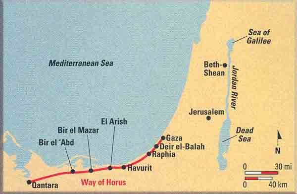
In the early 1970s, a survey of the Negev led by Eliezer Oren of Ben-Gurion University identified more than 80 New Kingdom sites in northern Sinai—ample evidence of the systematic settlement of the area by Egypt. The survey delineated three main types of settlements—administrative, military and industrial. From the Amarna period, three especially important complexes have been identified: (1) Bir el ‘Abd, midway between the Suez Canal and Gaza, which has a water installation and four cylindrical mudbrick silos; (2) Havurit, in northeastern Sinai, which contains storerooms, a courtyard and a potter’s workshop; and (3) Deir el-Balah. Similar settlements have been found on Egypt’s southern border with Nubia.
The accumulating evidence supports the theory that Akhenaten’s reign was characterized by continued Egyptian efforts to protect the country’s borders and to maintain stability throughout the empire. Deir el-Balah, located at the farthest border of Egypt, just outside the entry to Canaan at Gaza, is part of this picture: Clearly, Deir el-Balah served as an Egyptian administrative center. Its population was predominantly Egyptian, although the residents interacted with the Canaanites of the area and were influenced by the local culture.
On top of the governor’s residence, in effect superimposed on it, was a fortress from a later stratum (Stratum VII). The fortress was square, about 64 feet by 64 feet, and had 14 rooms. Its 6-foot-thick walls probably supported a second story. Its four corner bastions indicated that it had been built in a well-known royal Egyptian style. Strikingly similar fortresses can be seen on the reliefs of Pharaoh Seti I (1318–1304 B.C.) on the walls of the Amon temple at Karnak. The reliefs depict the ancient route from Egypt to Canaan, known then as the Way of Horus. They provide an almost exact blueprint of the kind of structure we excavated at Deir el-Balah. The close proximity of fortresses and water installations is seen at several stops along the route, as depicted on the Seti reliefs. Two of the fortresses shown on the Seti reliefs are designated as towns that “His Majesty newly built.” The Stratum VII fortress at Deir el-Balah may well have been one of these.
Although the fortress appears to have been built by Seti I, the pottery we discovered provides clear evidence that it was also used by his son and successor Ramesses II (1304–1237 B.C.). The anthropoid coffins we discovered also date to the reign of Ramesses II.
During the New Kingdom, northern Sinai was a kind of no-man’s-land. Nevertheless, the Way of Horus remained the most important land link with Canaan. As Sir Alan Gardiner, one of the most outstanding British Egyptologists, noted in his seminal work on the Way of Horus,“There can be little or no doubt but that the road from El-Kantareh [Qantara] to Gaza via Rafa [Raphia] has witnessed the marches of nine-tenths of the armies that have sought to invade Palestine from Egypt, or Egypt from Palestine.”3 While the Egyptian starting point at Sile (modern Qantara) is well recognized, the identification of the route’s terminus is less clear-cut. Biblical and historical sources name the “Brook of Egypt” as the border with Canaan, but the identification of this site is disputed. The traditional identification is the Wadi el-Arish; more recently, scholars have suggested that the border lay farther to the north, closer to Gaza, at the Wadi Shihor.4 Obviously, Gaza, the New Kingdom capital of the province of Canaan, lay within Canaan. Deir el-Balah, a mere 10 miles southwest of Gaza, may have been the last Egyptian outpost along the Way of Horus.
In later periods the water reservoir at Deir el-Balah became choked with debris and was filled in. An industrial area, including kilns, was built over it. The artisans’ quarter of Strata VI through IV was located in this area above the reservoir. It included domestic quarters and typical kitchen installations with clay ovens (tabuns) and cooking pots. We also found large fragments of coffins and a flat, perforated clay disk of the size and thickness of a coffin base. It was similar to a coffin base we had discovered in the cemetery, thus providing a possible link. We uncovered a lid fragment with the distinctively shaped mouth and nose of a well-known coffin type from the cemetery. We excavated hoards of bronze nails and scraps; a carved stone fragment of a nude reclining woman, a type of figurine known as a “divine concubine,” which was placed in tombs to serve the deceased in the afterlife; and spinning bowls used in the production of textiles. The fiber spun at Deir el-Balah was, in all likelihood, flax, since linen traces clung to the bronze objects we found in the coffins. We also found chunks of ocher for coloring the coffins. Some of the ocher was still in the stone bowls in which it was ground.
Thus, we found traces of nearly every craft connected with the production of the coffins and their burial gifts.
Later, during the 12th and 11th centuries B.C., Deir el-Balah was an unfortified Philistine settlement, as shown by the typical Philistine pottery. This marked the beginning of the end of the Egyptian domination of the site. At first, the Egyptians settled the Sea Peoples, including the Philistines, in these strongholds as mercenaries. Eventually, the Philistines threw off the Egyptian yoke.
Above the Philistine level were finds from the Israelite period, dating from the tenth to the ninth century B.C., after which the sand dunes reigned supreme for about 1,300 years. In its heyday, however, 3,500 years ago, the residents of Deir el-Balah flourished in a period of intensive international trade, political upheaval and ethnic interchange. The Late Bronze Age reflected a cosmopolitan culture, in which influences from Egypt, Canaan, Cyprus and the Aegean freely mixed, mutually enriching one another.
MLA Citation
Footnotes
The Middle Kingdom and New Kingdom are periods in Egyptian chronology. They are roughly equivalent to the Middle Bronze Age (2200–1550 B.C.) and the Late Bronze Age (1550–1200 B.C.) in Palestinian chronology.
Author Trude Dothan, working on behalf of the Institute of Archaeology at Hebrew University, and Osnat Misch-Brandl and Bella Gershovich, of the Israel Museum, are preparing to publish the anthropoid coffins and burial gifts illicitly excavated from Deir el-Balah and now housed in the Israel Museum. The publication of this catalogue will be the final stage in Dothan’s study of this unique site.
The archaeological expedition at Deir el-Balah was carried out by the Institute of Archaeology of Hebrew University and was headed by myself. I would especially like to mention a number of the participants who were involved with the excavations and publications of the cemetery and settlement: Baruch Brandl (field archaeologist and stratigrapher), Gary Lipton (surveyor), Ann Killebrew (field archaeologist), Bonnie Gould (pottery registrar), and Zev Radovan (photographer).
The cemetery was published in Qedem 10 (1987). Two additional volumes in the Qedem series (a completion of the report on the cemetery and the settlement) will be published shortly.
He published the following articles in BAR: “Edomites Advance into Judah—Israelite Defensive Fortresses Inadequate,” BAR 22:06; “The Route Through Sinai—Why the Israelites Fleeing Egypt Went South,” BAR 14:03; “New Light on the Edomites,” BAR 14:02; and “Fifteen Years in Sinai,” BAR 10:04.
This process determines the chemical composition of an object. See Maureen F. Kaplan, “Using Neutron Activation Analysis to Establish the Provenance of Pottery,” BAR 02:01.
See, for example, Carolyn R. Higginbotham, “The Egyptianizing of Canaan: How Iron-Fisted Was Pharaonic Rule in the City-States of Syria-Palestine?” BAR 24:03.
Endnotes
James M. Weinstein, “The Egyptian Empire in Palestine: A Reassessment,” Bulletin of the American Schools of Oriental Research 241 (1982), pp. 1–28, esp. p. 17.
Hanoch Raviv, “The Planning of an Egyptian Campaign during the Days of Amunhotep IV,” Yediot Bahaqirat Eretz Israel Weatiqotea 30 (1966), pp. 45–51 (in Hebrew).
Alan H. Gardiner, “The Ancient Military Road Between Egypt and Palestine,” Journal of Egyptian Archaeology 6 (1920), pp. 99–116.
