
We knew this wouldn’t be easy. Very steep, far from any paved roads, and secluded by several streams to cross, the archaeological mound of Tel Rekhesh poses serious challenges to anyone wanting to uncover its secrets. These isolating factors certainly contributed to the fact that Tel Rekhesh has been occasionally surveyed, but never excavated … until now.
When we first visited Tel Rekhesh, in August 2004, we contemplated the potential hardships of excavating the site. And we decided to go ahead, hoping that we would be rewarded. We struck the first spade into the ground in March 2006—with wildflowers blooming everywhere and butterflies flittering around us.1 Unfortunately, the first rain subsequently made the access road so muddy that we could not reach the site and had to pause excavation for a few days at a time. Since then, we usually work in the heat of summer.

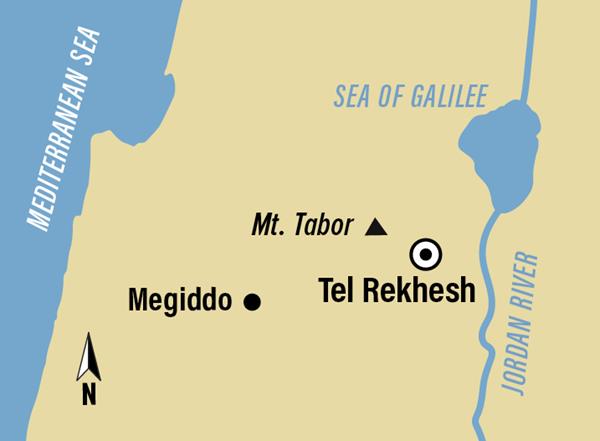
Tel Rekhesh is located at the confluence of the perennial rivers Nahal Tavor and Nahal Rekhesh, which provide sufficient water supply for nearby populations. This geographical feature was a main reason for Tel Rekhesh’s nearly continuous settlement from the Early Bronze Age to the early Roman period—some 3,000 years.2 Its topography was another reason: Being enclosed by these two rivers and the surrounding steep slopes was highly advantageous for security.
Set within the Mt. Tabor Nature Reserve and National Park, the roughly triangular mound covers about 400,000 square feet, making Tel Rekhesh one of the largest archaeological mounds in the Lower Galilee. It comprises two parts: the acropolis (the higher mound), measuring about 50,000 square feet, and a lower part surrounding it.
Second Kings 17 describes the conquest of Samaria, the capital of the Kingdom of Israel, by the Assyrian king Shal-maneser (c. 722 B.C.E.). Conquered and exiled, the northern kingdom disappeared from the arena of history. What followed in the northern kingdom’s former territory? Most histories of ancient Israel do not provide a detailed narration of the land and its inhabitants. The Hebrew Bible, crafted from the Judean point of view in the southern Kingdom of Judah or in the province of Yehud under Persian rule, does not provide much information about the northern region after the fall of Samaria. It reports only that people deported from Mesopotamia and northern Iran settled there and that they participated in the cult of the local god Yahweh—but worshiped him incorrectly (2 Kings 17). There is also a handful of epigraphic sources. However, none of this is sufficient for reconstructing a comprehensive picture of the region’s history.
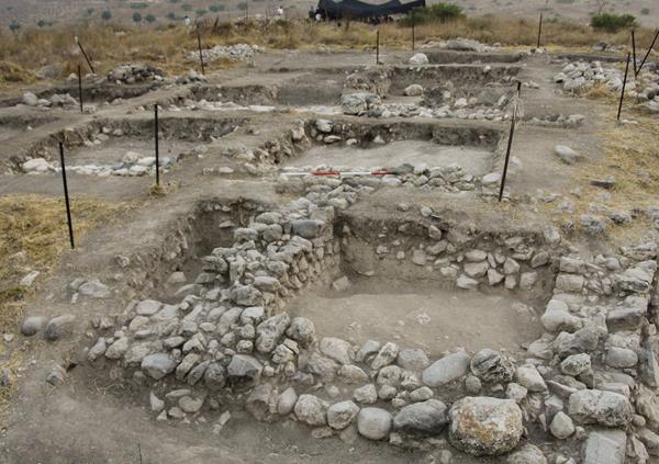
Our excavations at Tel Rekhesh have revealed a late Iron Age monumental building complex that seems to be related to this enigmatic period. Measuring about 115 by 180 feet, the complex covers nearly half of the acropolis and occupies its southern part. The inner wall of the structure has a wide opening, flanked by boulders, that leads into a paved space (6.6 by 10.8 ft) to the north, possibly an open courtyard.
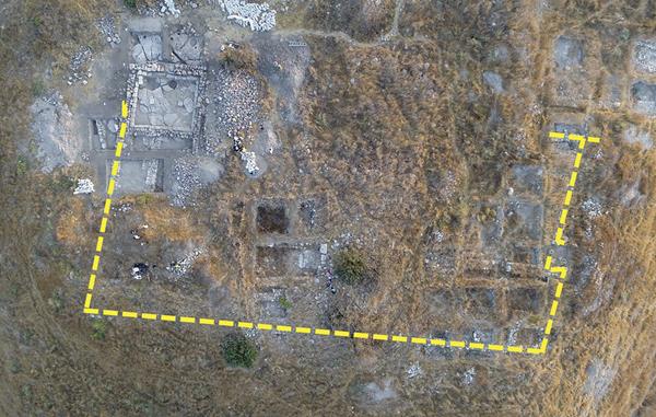
The eastern and the southern enclosing walls of the complex formed the corner of a small room (13 by 13 ft). From this room, we excavated large amounts of thick, gray plaster, some of which resemble rounded sections of a plastered bathtub. This type of room at the corner of a building is known from courtyard structures of the Assyrian and Babylonian periods, such as at Arslan Tash (ancient Hadātu) on the border between modern Syria and Turkey.
The eastern perimeter wall extends 50 feet from the southeastern corner of the building complex to the north. A 27-foot-wide gap in the wall appears to have been an entrance.
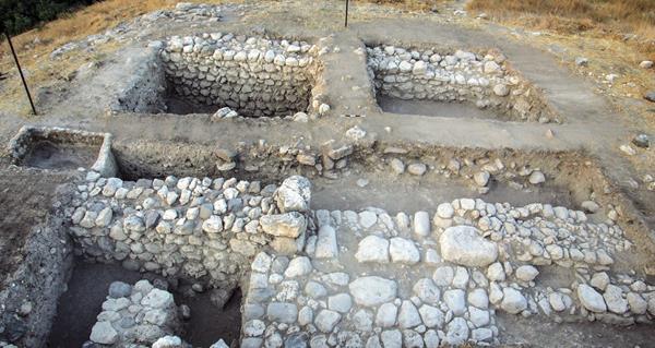
We found a peculiar feature at the southern end of the building complex: a three-stepped white plaster installation about 30 feet north of the complex’s outer perimeter wall. The stepped structure had been badly damaged by later Roman building, but it was preserved to a height of 2 feet and a width of 7.2 feet. This installation abutted a late Iron Age wall to the north and covered its southern face. The steps descended in the direction of Mt. Tabor, at the eastern end of the Jezreel Valley.
Below the white plaster, we found a core of small stones mixed with fill soil. The lowest plaster tread was preserved to a width of only 3.3 feet, destroyed by the construction of a pit in the early Roman period. At the eastern end of the plastered structure, we exposed a wall of basalt and limestone with a trace of a thin line of plaster. A Roman period wall had been superimposed on this wall.
Discussion of this stepped structure’s date is still ongoing. Since the pottery collected from the level on top of the structure was mixed and contained a large amount dated to the early Roman period, we do not have a clear date for it.
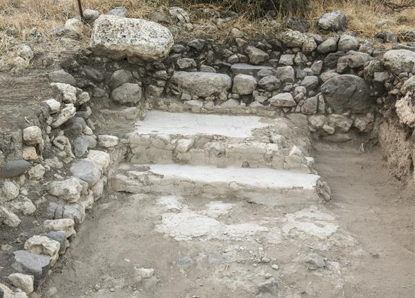
On the western part of the acropolis, we had excavated an assembly hall, which is most probably a synagogue. Because of that discovery, one of the present authors (Kuwabara) regards the stepped structure as a possible ritual bath (mikveh), related to the assembly hall.3 Material culture, including coins, chalkstone vessels, and Herodian lamps, suggests that there was a Jewish settlement on the acropolis of Tel Rekhesh in the first and second centuries C.E.
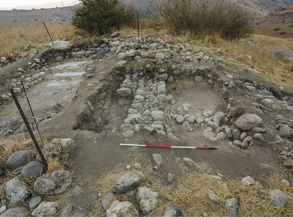
If this dating of the stepped structure is correct, then the Jewish community constructed it in the early Roman period, reusing the late Iron Age wall for its northern wall. However, the question remains whether this structure could have served as a mikveh. It is uncommon to build a mikveh on top of an earlier structure. And according to the requirements of Jewish religious law, a mikveh should be at least partly hewn from rock.

The other two authors (Hasegawa and Paz) therefore think that the stepped structure was built during the late Iron Age as a ceremonial bathroom—similar to the one in the complex’s southeastern corner—or as a pool. Only later, during the early Roman period, was it reused as a refuse pit or for an unknown farmstead purpose. From the sounding made within this installation below plaster level, we retrieved no Roman potsherds but collected many Iron Age sherds.
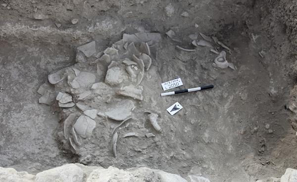
The dating and identification of the entire complex has proven somewhat problematic. From the top of the pavement and related areas, we collected late Iron Age II (700–586 B.C.E.) and Persian period (539–332 B.C.E.) pottery, including a large quantity of torpedo jars (long, narrow storage jars resembling the underwater missiles) and mortaria (hemispherical or conical bowls with gritty internal surfaces used for pounding or mixing foods) made from orange clay. These led us to date the building complex roughly to the late Iron Age II period.
But then, at the southwestern part of the complex, we found a rock-cut installation beneath the packed-earth floor of the late Iron building. Within the installation, we collected small amounts of Iron Age IIA–IIB (1000–700 B.C.E.) sherds, including a restorable cooking pot and a dipper juglet. On top of the earthen floor, we retrieved Iron Age IIC (700–586 B.C.E.) sherds. It is, therefore, reasonable to date the complex to the Iron Age IIC, that is, the seventh to the sixth centuries B.C.E.
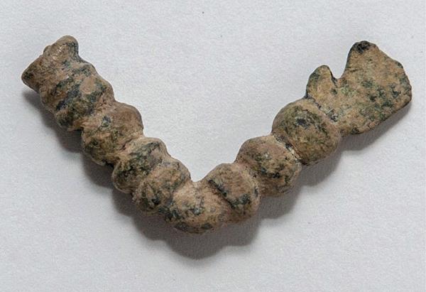
Other finds from the outside of the complex seem to support this conclusion: a fibula (for fastening garments) of a type centrally distributed in Mesopotamia dating to the seventh century B.C.E. and two Scytho-Iranian arrowheads—one dating from the late seventh to early sixth centuries B.C.E. and the other dating from the early sixth to early fourth centuries B.C.E. The earlier arrowhead is of the same type as one found in a destruction layer in Jerusalem, possibly related to the Babylonian attack of the city in 587/6 B.C.E. The room with plaster—or perhaps rooms, if we count the stepped plaster structure—also reminds us of Assyrian and Babylonian buildings. All these finds show that people from Mesopotamia likely inhabited the site.

Considering these findings, this complex was probably built under the rule of Assyria or Babylonia—the two large political powers that dominated the area in the seventh and sixth centuries B.C.E.
However, several questions about this monumental building complex still need answers. The northern part of the complex has been destroyed by an extensive building that took place in the early Roman period. Unlike other major Iron Age sites, such as Megiddo or Hazor, Tel Rekhesh is not located on major super-regional routes. This makes the function of the isolated building complex at Tel Rekhesh somewhat mysterious.

We only tentatively identify this structure as a public building used primarily as an administrative center. It is our best guess for a structure so removed from major trade routes and urban centers. Continued excavation of the complex may bring more data necessary to reconstruct the history of the region following the demise of the northern Kingdom of Israel. And so we will continue to dig the tell that is over the hills and far away.

